About Milam Glacier
Milam Glacier is the source of the Gori Ganga River which acts as an important tributary of the Kali River. The trek is long, tiring and adventurous and thus graded at a moderate level. Milam Glacier is situated 60 kms from Munsiyari. The trek to Milam Glacier offer mesmerizing Himalayan views that take one through verdant meadows, lush green valleys, waterfalls, pine forests, and isolated hamlets to reach Milam glacier.
The trek involves moderate walks to cross the hills, walk along with the Gori Ganga River and rugged terrains. The trail offers captivating view of quaint villages, picturesque streams, waterfalls, and the snow-laden Himalayas. The route to Milam glacier has several vantage points offering panoramic vistas of mountains, friendly people, varied flora and fauna and green landscapes.
Location of Milam Glacier
Milam Glacier is situated at the base of Mount Trishuli (7065 mts). Provision for food, porters, and guides can be done from Munsiyari. Milam Glacier is perched at an elevation of 3438 mts above sea level, 60 kms beyond Munsiyari. The trail to Milam Glacier goes through forests, waterfalls, villages, chunks of ice, wooden bridges.
Milam Glacier is one of the remotest yet accessible glacier trek in all of Uttarakhand. The vastness of peaks of Hardeol (7,151m), Mangraon (6,568 m), and Deo Damla (6,637 m), and Sakram (6,254 m) can be experienced from the Milam glacier. The glacier itself is the source of the Goriganga River which is an important tributary of the Kali River.
Milam Glacier Suggested Trek Itinerary
Day 01: Kathgodam - Almora - Munsiyari
Driving: 340kms, 10hrs
Start early in the morning from Kathgodam to reach Munsiyari by evening. Drive via Almora and Bageshwar and purchase necessary equipments and things of your need. Reach Munsiyari before dark. Munsiyari is a popular hill station of the Kumaon region situated at an elevation of 2,290mts and it acts as the base camp for Milam Glacier trek. Overnight in Munsiyari
Day 02: Munsiyari - Lilam
Trekking: 14kms, 6hrs, Level: Easy
After breakfast drive to Seolikote from where the trek to Milam glacier commences. The route gradually descends for around 3kms with trail alongside the gushing Gori Ganga River. The trek goes through the mixture of forests and fields along the way. The last kilometers before Lilam demand a steep climb. Lilam is situated at an altitude of 1,850mts above sea level. Overnight in Lilam.
Day 03: Lilam - Bogudiyar
Trekking: 2kms, 5hrs, Level: Easy
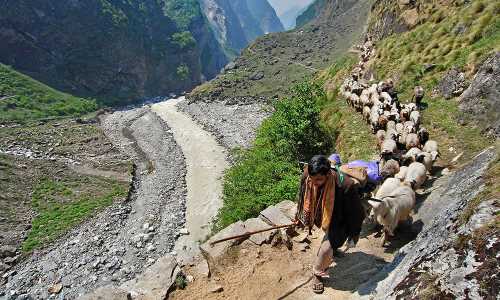
The trail from Lilam to Bogudiyar has some ups and downs with increasing altitude. Watch shepherds grazing their animals on the beautiful green meadows. After a steep uphill climb you will reach Bugdiyar. Bugdiyar is a beautiful place set at an elevation of 2,500mts above sea level. Overnight in Bugdiyar.
Day 04: Bogudiyar - Rilkot
Trekking: 12kms, 5-6hrs, Level: Moderate
Today's trek goes through mule bridges, granite rock faces, frozen ice streams and a final steep ascent to the village of Rilkot. Rilkot is situated at an altitude of 3,130mts above sea level. En route one can divert to the Laspa village and further to northern glacier of Nandakot. Rilkot is a beautiful place for camping, guarded by huge cliffs on both side.
Day 05: Rilkot - Martoli - Milam village
Trekking: 16kms, 7hrs, Level: Moderate
After early breakfast start trek to Martoli. Martoli is a scenic place situated at an elevation of 3,430mts above sea level. The route to Martoli from Rilkot is a steep climb of about 7kms. Martoli was part of the ancient silk route of Tibet in ancient times. After walking a few kilometers from Rilkot the route diverts to two paths, one going up and the other down. Follow the downward trail. Burfu and Martoli are mid points of the trek. See the ruins of old village of Rilkot while trekking to Milam Village. Cross the river on a wooden bridge and walk for about half an hour to reach Burfu. After trekking for a few kilometers you reach Milam Village. It is the last village on the route to Milam Glacier and is also one of the remotest villages of Uttarakhand state. Milam Village is situated at an elevation of 3,420mts above sea level. Overnight in Milam village.
Day 06: Milam village - Milam Glacier - Milam Village
Trekking: 6kms, 2hrs, Level: Moderate
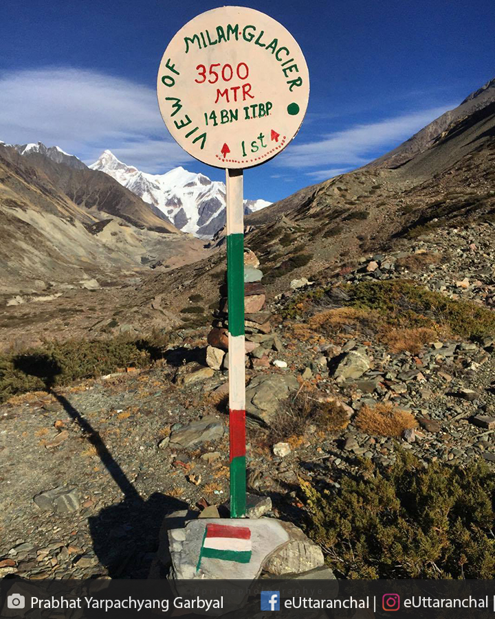
Wake up early to see the enchanting views of Trisuli (7,065mts) and other snow laden Himalayan peaks. After breakfast head towards the gigantic Milam Glacier. The 3km trekking route for the day goes through rugged terrains. Milam Glacier is situated at an elevation of 3,438mts above sea level covering an area of 37sq.kms. This 10km long glacier is the source of Goriganga River. After exploring the beauty of this heavenly site return back to Milam Village. Gaze at the Himalayas in the evening. Overnight in Milam Village.
Day 07: Milam Village - Rilkot
Trekking: 16kms, 7hrs, Level: Moderate
Trekking back from Milam village to Rilkot is quite enervating as it goes through ups and downs. But the scenic views will surely make you think about the existence of the place called heaven. Overnight in Rilkot.
Day 08: Rilkot - Bogudiyar
Trekking: 12kms, 5hrs, Level: Moderate
As you trek down the route will become easy but also tiresome. Walk slowly and steadily from Rilkot to Bugdiyar enjoying the enchanting view of grasslands, streams and waterfalls. Walking too fast may lead to pain in your thighs and foot joints. Overnight in Bugdiyar.
Day 09: Bogudiyar - Lilam
Trekking: 12kms, 4-5hrs, Level: Easy
Enjoy the gradually descending trek from Bugdiyar to Lilam from 2,500mts to 1,850mts above sea level. Overnight in Lilam.
Day 10: Lilam - Munsiyari
Trekking: 14kms, 5hrs, Level: Easy
Start your final steps of this unforgettable and adventurous trek. Trek back towards Munsiyari. Overnight in the picturesque hamlet, Munsiyari.
Day 11: Munsiyari - Kathgodam
Driving: 340kms, 10hrs
Drive back to Kathgodam from Munsiyari and carry back memorable moments.
What is Milam Glacier famous for?
Milam Glacier is famous among tourist as Trekking .
Milam Glacier is recommended destination for Foreigners, Groups.
Milam Glacier is popular destination for following activities/ interests - Adventure, Glaciers, Trekking.