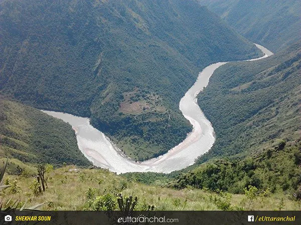
The Kali River also known as “Sharda River”, “Kutiyangdi” or “Mahakali River” is a Himalayan river, which flows through Uttarakhand. The traditional source of Kali River is LipmpiyaDhura in Pithoragarh district of Uttarakhand, 3,600 metres about 11,800 feet above sea level. The length of this river is 252 km and the basin area is 18,140 square km. Kali River is the headwater stream of the Mahakali River.
The river got its various names from the inhabitants, residing on the different side of the Indo-Nepal border. The Kali River is referred to as Kali Gad or Kali Ganga in Uttarakhand, where it separates Nepal’s western border with India. Below the Nepal-Uttarakhand border Kali River enters Uttar Pradesh state and flows in the southeast direction, across the plains to join Ghagra River, which is a tributary of Ganga. Kali River receives the right-bank Dhauliganga (often confused with Alaknanda tributary) at Tawaghat.
The river flows through Dharchula and receives the Gori Ganga at Jauljibi. Chameliya, the first left-bank tributary from Nepal joins after flowing southwest from Nepal’s Gurans Himal, including Api. Then it meets the Saryu River. The area which sprawls around Pancheshwar is called Kali Kumaon.The Kali leaves the Hill Region at Jogbudha Valley and meets the two tributaries namely Ladhiya and Ramgun.
Then it enters the lower Shiwalik Hills. There is a tiny hamlet called Tanakpur, located above the Dam of Sharda Reservoir. The water of this river is diverted into an irrigational canal. The river exits the last hills into the Terai plains and crosses two towns namely Banbasa and Mahendranagar also known as Bhim Datta.The Kali River descends from 3,600 meters about 11,800 feet at Kalapani to 200 meters around 660 feet on entering Terai plains.
The water of this river is also used for hydroelectric power generation. Kali River is also the source for a vital project, in Himalayan component of the Indian Rivers Inter-link project. The Lower Sharda Barrage is constructed on Sharda River, about 163.5 km downstream of the Upper Sharda Barrage, nearly 28 km from Lakhimpur city. Tanakpur Hydro Electric Project is a vital river scheme on Sharda River, located near the town of Tanakpur in the district of Champawat. Also, Chameliya Hydroelectric Project, a daily peaking run-off-river (PROR) scheme with an installed capacity of 30 MW, has been taken up for construction since January 2007.