Travelogue: Kedartal - Patangini Dhar with Audens Col

Travelogue By: Col R S Sidhu
Date of Travel: 28 Sep to 5 Oct 2019
India is on the move into the snowy heights of the Greater Himalayas, from the West to the East. It is interesting to note that both young and the ‘old’ are equally part of this gathering movement. People into their 70’s and family groups are frequently seen on adventures in this terrain.
During a family gathering, where I was not having my way in the discussion at hand, and to grab attention I sombrely declared aloud my intention to accompany my younger son-in-law Rohan on his forthcoming long trek. To my surprise I faced no opposition from my well-meaning family and well-wishers. The cat was out of the bag and no putting it back in!
But a Root Cause Analysis of my underlying intentions would probably end up pointing towards my own words written a decade ago. They are penned at the end as Prologue, and only for serious thinkers! Probably at this juncture of my life I may have progressed to the self-actualisation stage in the “Maslow’s Hierarchy of Needs” theory. Only time will tell. The only reason I have touched upon the motivational impulse is for the benefit, if any, of other’s in my age profile.
Whatever be the motivational impulse, it commenced my entry into the world of trekking at the exciting young age of 65 years. I plunged head on to research my “new found passion” and commenced active preparations. Yoga & meditation along with functional fitness regime formed the basis for preparing the body and mind for the arduous days ahead. An 8 kgs backpack became my constant companion during early morning walks of 8 kms per day in rolling countryside. 3 – 4 weeks of regular practise made me feel in fine fettle to take on the rigours of the long trek, or so I thought!
THE TEAM
The Regulars
- Sandy, 30 years, Dehradun (Team Co-ordinator, from eUttaranchal.com)
- Nitish, 29 years, Chandigarh
- Rohan, 37 years, Mumbai
- Anjali, 28 years, Delhi
Experienced Geriatrics
- Tony Yan,70 years, Las Vegas, USA
- Yui Sun Yan, 77 years, Wisconsin, USA
New Entrants
- Varun, 29 years, Chennai
- Self
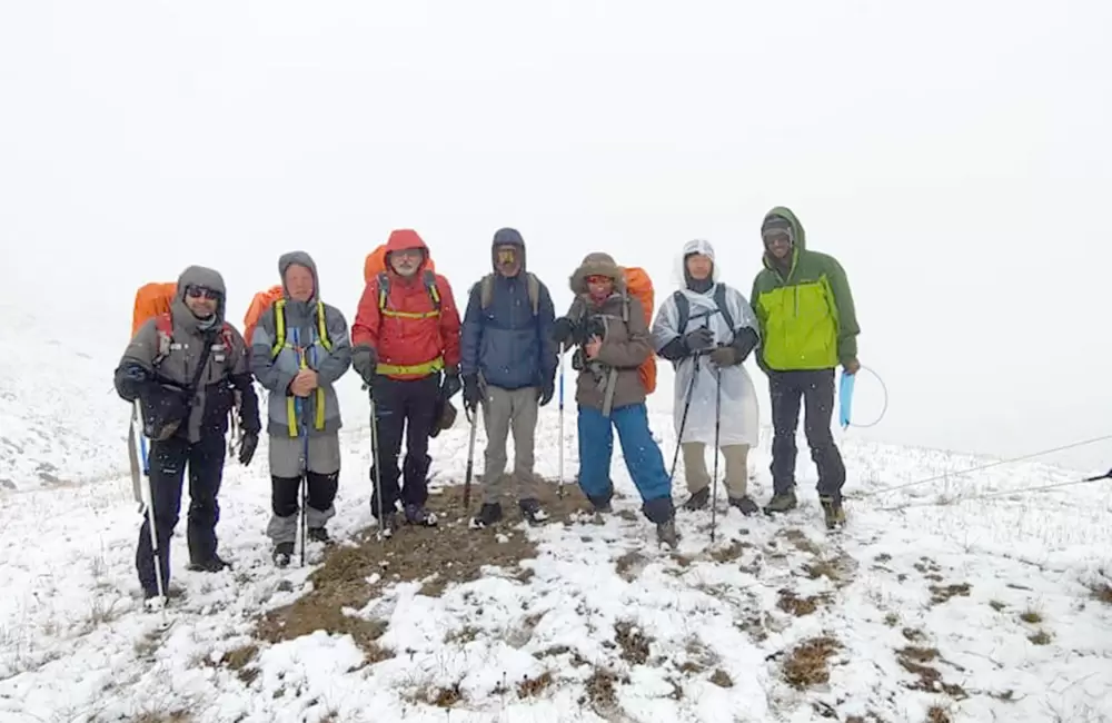
There was wide disparity, within the team, in terms of experience and age. Sandy, Nitish, Rohan and Anjali are regulars on the trek circuit and have worked as a team. Tony and Yui have trekked, literally, in almost all the continents. They were highly experienced trekkers but were now in their twilight years. In deference to their age, it was understood that they shall not be weighed down by carrying their backpacks. Varun and self were unknown quantities, as this was our first trek.
Mahavir, 40 years, from Uttarkashi was our guide for the trek. We could not have asked for a better guide. Highly experienced, mature and a well-balanced personality. He is Advanced Mountaineering Course (AMC from NIM, Uttarkashi) qualified and knows the terrain like the back of his hand. As per the grapevine he is credited with completing the 16 days Gangotri- Kedarnath trek in 6 days, with night halts at Rudragaira – Auden’s base – Khattling – Chauki – Masartal - Kedarnath.
Actual Route - Distance and Altitude | |||||
| Day | Route | Height (mts) | Distance (kms) | Time (hrs) | Major Altitude Gain |
| 1 | GangotriTown (Start Point) | 3010 | 7 | 4.30 | 10,100’ |
| Bhoj Kharak | 3680 | | | | |
| 2 | Bhoj Kharak | 3680 | 7 | 4 | |
| Kedar Kharak | 4200 | | | | |
| 3 | Kedar Kharak | 4200 | 5 | 2.30 | |
| Kedar Tal | 4700 | 5 | 1.30 | 15,666’ | |
| Kedar Kharak | 4200 | | | | |
| 4 | Kedar Kharak | 4200 | 5 | 4 | |
| Patangini Dhar Base Camp | 4650 | | | | |
| 5 | Patangini Dhar Base Camp | 4650 | 1.5 | 3.15 | |
| Patangini Dhar | 4915 | 4.5 | 4.30 | 16,383’ | |
| Rudragaira Upper Nala Camp | 4350 | | | | |
| 6 | Rudragaira Upper Nala Camp | 4350 | 10 | 7.30 | |
| Gangotri Town | 3010 | | | | |
| | Total | | 45 | | |
MOVE TO GANGOTRI
Tony and Yui moved to Gangotri on 26 September so as to acclimatise themselves for the trek. Balance of the team assembled at Dehradun on 28 September and moved to Gangotri in a 12 seater Tempo Traveller. The route we travelled on was Dehradun – Mussoorie – Chinyalisaur – Dharasu – Uttarkasi – Gangotri (242 kms).It was in a good state, excepting for a few patches, making the journey a comfortable one. The road passed through lush green hills and after Uttarkasi it followed the course of the River Bhagirathi, making it a picturesque journey. We left Dehradun by 0900 hrs and reached Gangotri by1900 hrs. Enroute Sandy took time off at Uttarkashi to make purchases of dry and fresh rations for the trek. The 10 hours journey was very pleasant.
On our arrival at Gangotri we were greeted by light, intermittent drizzle. Little did we know that intermittent drizzle/snowfall would be our constant companion during the trek. After unloading our baggage into a lodge we proceeded to the famous Ganga Temple to pay our obeisance. The tourist inflow had already fallen, enabling us to have a leisurely darshan of the revered deity.
Gangotri, located at an altitude of 3010 metres (10,100’), is a pretty and quaint town, with River Bhagirathi flowing through it from North to South. To its North-West lies the Nelang Valley, and its relatively unexplored peaks, being a restricted area. The Kedar Ganga, originating from the glaciers surrounding Kedar Tal in the South Easterly direction, joins the Bhagirathi River at Gangotri. A Nala emanating from Rudragaira, in South Westerly direction, joins the River Bhagirathi approximately a kilometre downstream from Gangotri.
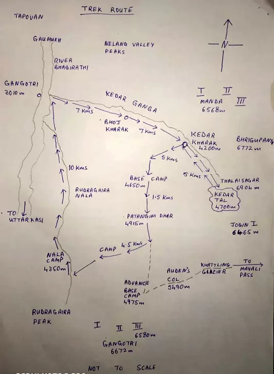
From Gangotri there are two popular trek routes. Along the River Bhagirathi to Gaumukh and beyond to Tapovan is the most popular and relatively easier. Following the Kedar Ganga to Kedar Kharak (while visiting Kedar Tal) is the slightly difficult route due to rock fall zones and broken scree areas. From Kedar Kharak one can cross into the Rudragaira valley via Patangini Dhar pass and Auden’s Col which is considered arduous and is seldom travelled.
Patangini Dhar, situated at an elevation of 4915 metres (16,383’), connects Kedar Ganga Valley to Rudragaira Valley. Auden’s Col, situated at an elevation of 5490 metres (18,300’), is the lowest point on the Jogin I - Gangotri III ridgeline and connects Rudragaira Valley to Khattling Glacier and beyond to Mayali Pass and onto Kedarnath. The trek route Gangotri – Kedar Tal – Patangini Dhar – Auden’s Col – Rudragaira Valley – Gangotri is circular like a garland and is so designed as to ease the requirements of acclimatisation, a critical factor in high altitude. The trek involves moving in a South Easterly direction from Gangotri along River Kedar Ganga, cross over the Patangini Dhar into Rudragaira valley and return along the Rudragaira Nala to Gangotri from the South West.
The trek route lies within Gangotri National Park and access to trekkers is controlled by the Forest Department. The permit for entry is issued by the Forest Office located in the middle of the town. However, trekkers above 58 years of age are also required to furnish a medical certificate issued by the Medical Officer Gangotri, co-located with the Forest Department Office.
TREK DAY 1 – GANGOTRI TO BHOJ KHARAK
It was drizzling since day break and the Forest Department go ahead was held up owing to inclement weather. The approval was finally granted at 1000 hrs and we promptly commenced our trek at 1030 hrs.
The path, though only upto 2’ wide, was well defined. Thick green cover restricted the view. The trek generally followed the alignment of River Kedar Ganga. The roar of its waters was to be our constant companion right till the Patangini Dhar Base Camp.
However, the impact of carrying a 12 kgs backpack at inclines of upward 45 degrees gradient, at altitudes above 3000 mtrs (10,000’), came as a shock. Day one was thus a big struggle! The intermittent rainfall did not help the matters at all. It made the ground wet and slipperyrequiring full concentration of all faculties in placing the feet on the trek path.
Wet and exhausted we reached the camping site of Bhoj Kharak (3680 mtrs/2,266’) by 1500 hrs. During this course of 7 kms/4 hrs and 30 minutes we had gained 670 mtrs (2,233’) in altitude. Nevertheless, there was a sense of accomplishment despite the tribulations of the journey.
The camping site has restricted space for camping. Just adequate for pitching 8-10 tents.A clear fresh water stream, approximately 50 mtrs away, provided adequate source of water supply. The sitewas open to the sky but had 3’-5’ of wild undergrowth. The roar of Kedar Ganga, flowing 100 mtrs below could be clearly heard.
A six member family trek group from Calcutta, and accompanying porters, were already camped at the campsite. They were on the Kedar Tal trek. Approximately 200 mtrs away was another trek party comprising of 3 highly experienced trekkers and 6 porters. They were preceding us on the Patangini Dhar- Auden’s Col trek. While on an acclimatisation hike at Bhoj Kharak camp, Rohan recognised a member from the second trek group who happened to be his Facebook friend. Strange are the ways of destiny. We discussed our similar objective of crossing Auden’s Col, while they planned to go further to Mayali Pass and reach Kedarnath.
Over dinner and close enquiries from the guide it emerged that the campsite was so named because of the presence of clumps of Bhojpatra trees at the site. Kharak is the term for Bakarwal deras. Hence the name Bhoj Kharak.
TREK DAY 2 – BHOJ KHARAK TO KEDAR KHARAK
We broke camp and commenced our move at 1000 hrs. There was no change to the weather. In fact the chill factor was enhanced because of a slight breeze and the altitude factor. The trek, as daunting as yesterday, had some silver lining. The country side opened up as we reached the tree line. The valley was filled with a riot of colours. Multi coloured leaves and flowers flooded the valley walls. Rocks amongst the grass ledges added multi-dimensional rugged beauty to the landscape.
Midway through the trek we crossed the tree line. The footpath got narrower. Shortly we began our descent to the Kedar Ganga river bed. That is when we encountered the rock fall zone and the infamous spider wall of Kedar Kharak. The footpath disappeared amidst the rock debris and we had to make our own way. The rocks were piled loose amidst shale which had slithered downslope. It was a treacherous 500 mtrs stretch, one person at a time. With concentrated effort we crossed it successfully.
Then we again commenced ascent. The air had become rarefied and it took greater effort to breathe. Suddenly we had reached the camping site at Kedar Kharak. A beautiful expanse of grass filled meadow, interlaced with snow fed flowing streams of clear water.
It was approximately 1400 hrs. It was drizzling, windy and cold. To add to the difficulty our porters had not yet reached. We were a porter short from Bhoj Kharak, necessitating redistribution of porter loads.
The trek of 7 kms was completed by the team in 4 hrs. The campsite was located at an altitude of 4200 mtrs (14,000’), a gain of 520 mtrs (1,733’) from the previous day.
TREK DAY 3 – KEDAR TAL & BACK
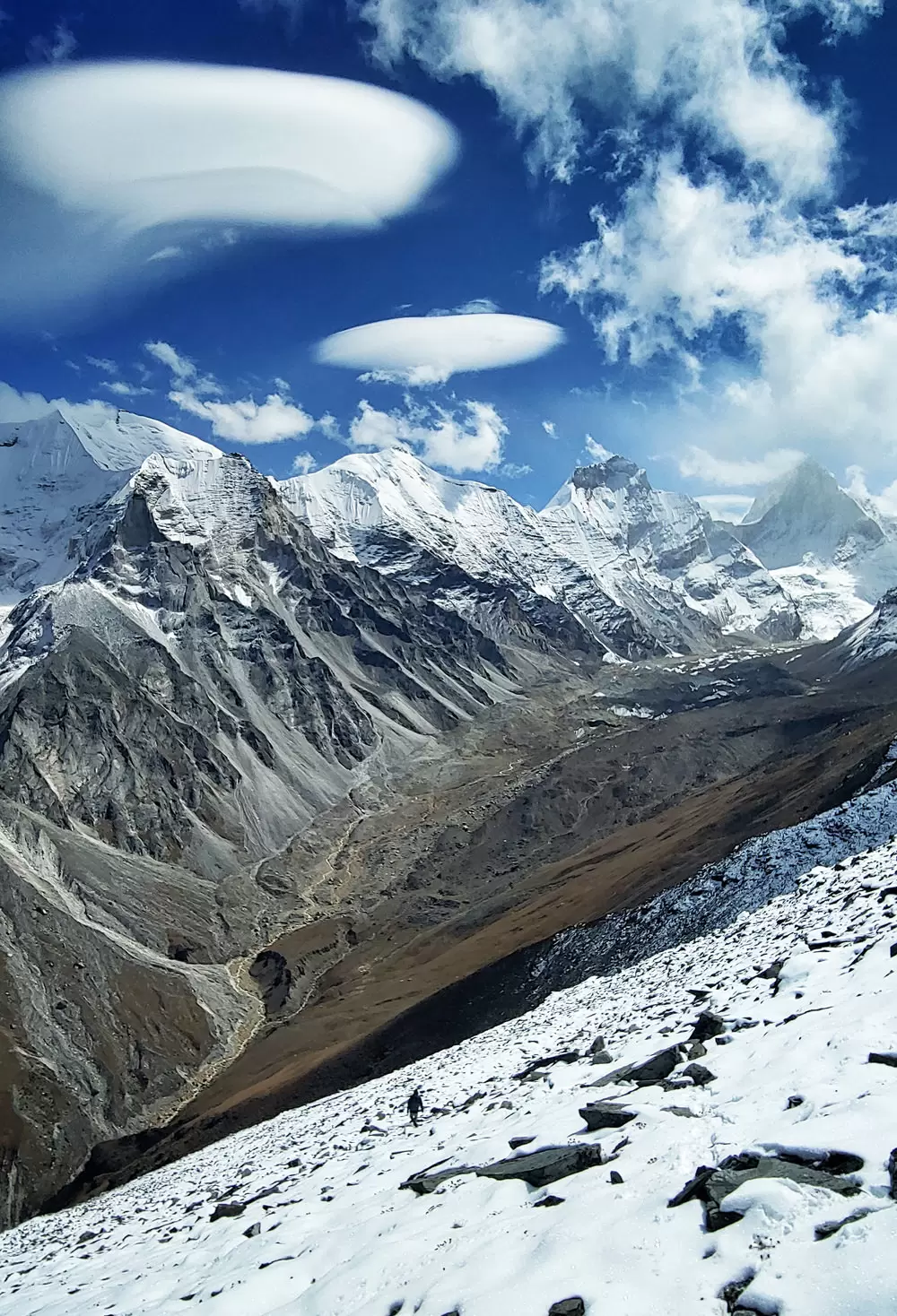
The day dawned with a beautiful sunshine. An awe inspiring vista of snow covered heights surrounded us. Nelang Valley peaks to the North glistened in the sunlight. Closer home, to our North East lay the grandeur of Manda, Bhrigupanth and Thalaisagar peaks, within hand clasping distance or so it seemed. Cameras were out in full force to capture the awe inspiring mountain-scape.
National Green Tribunal has prohibited camping at bugyals (grassy meadows). The trek to Kedar Tal was thus a to and fro day trek only.A big relief. This part of the trek, however, serves a very useful purpose. It assists in the acclimatisation process of the body and enables body to recoup lost energy by not carrying the heavy backpack for the day.
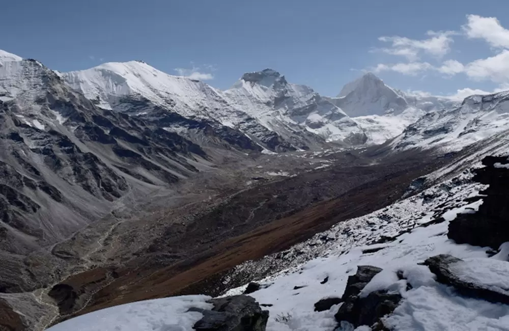
It was 1000 hrs by the time we commenced our trek to Kedar Tal. The gradients were comparatively gentle. The grassy path easy to tread. After a kilometre or so we heard the gentle gurgling of water. Snow was melting and water was making its way down through the stream beds. A picturesque sight. Then the landscape changed to broken rock and boulders reminiscent of a lunar surface. Kedar Ganga could no longer be seen or heard. It flowed quietly and unseen under the glaciers that were its source. The glaciers themselves were a mass of moraine and broken ice.
It took us 2 hrs and 30 mins to cover the distance of 5 kms to Kedar Tal. A mystic sight greeted us as we sat on the ledge looking down upon the Kedar Tal, roughly 200’ below framed by the dominating vista of Thalaisagar peak. Abode of the Gods is the phrase which instantly struck the mind.We walked down to the Tal to dip our hands into its watersand offer our prayers.
Lying at a height of 4700 mtrs (15,666’) it provided valuable acclimatisation for 5000 mtrs plus altitude.
After approximately an hour halt, it started snowing. That was the signal for us to commence our return to Kedar Kharak. Light snowfall kept us company till we reached our camp site, which we reached by 1500 hrs. The return journey took us 1 hr and 30 mins.
TREK DAY 4 – KEDAR KHARAK TO PATANGINI BASE CAMP
The route to the base Camp for Patangini Dhar lies off the beaten trek of Gangotri-Kedar Tal. There is no visible pathway. We commenced our move at 1000 hrs. The sky was overcast and it rained intermittently. It was windy and chilly even in daytime.
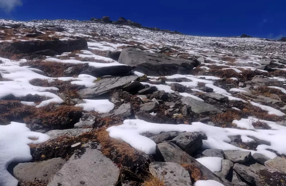
Initially the slopes were covered with thick grass, slowly giving way to more rocks. We came across three tricky hilly stream crossings requiring extreme caution. And then came the most treacherous part of the trek. Loose rocks not discernible in thick grass and a 55 degree gradient. With bent backs we laboured for further 2 hrs before reaching the camp site, an open ledge at the base of Patangini Dhar. A running stream approximately 300 mtrs away was the only available water source.
We reached campsite by 1400 hrs. It took us 4 hrs to cover the distance of 5 kms. It was the stiffest climb so far. The campsite was located at an elevation of 4650 mtrs (15,500’), a gain of 450 mtrs (1,500’).
Looking back we could see our Kedar Kharak camp site. A fresh set of tents had been pitched signifying arrival of another group on the Kedar Tal route. We met them subsequently on our return journey to Dehradun. A corporate group of 6-8 trekkers. Kedar Tal and its accompaniment of peaks were covered with clouds. Even at this height and distance the roar of the Kedar Ganga could be distinctly heard.
Looking upwards in the direction of Patangini Dhar we could see the faint silhouettes of tents which belonged to the trek group that preceded us. They had planned to cross Patangini Dhar pass the same day, however, inclement weather may have had a bearing on their plan.
Brahm Kamal – The day’s narrative would not be complete without a few lines on Brahm Kamal (celestial flower), the State Flower of Uttarakhand. We were fortunate during the day to come across this species in its natural habitat. Though the flowering season of this plant was already over, it still had a mystic aura around it. We held it with reverence in our hands. Generally found at altitudes of around 4500 mtrs in the Himalayas,it flowers just once a year during July-August. It is not easy to witness it bloom because it flowers, after sunset, in the late evening and stays only for a couple of hours.It is long held belief that anybody who sees this rare flower blooming will have all his or her wishes fulfilled. We certainly had our wish fulfilled by being granted a six hour window, on the ensuing day, to ascend Patangini Dhar.
TREK DAY 5 – PATANGINI DHAR – RUDRAGAIRA VALLEY
The day dawned with a beautiful clear sky. We decided to immediately avail of this God given opportunity and started the ascent at 0815 hrs.
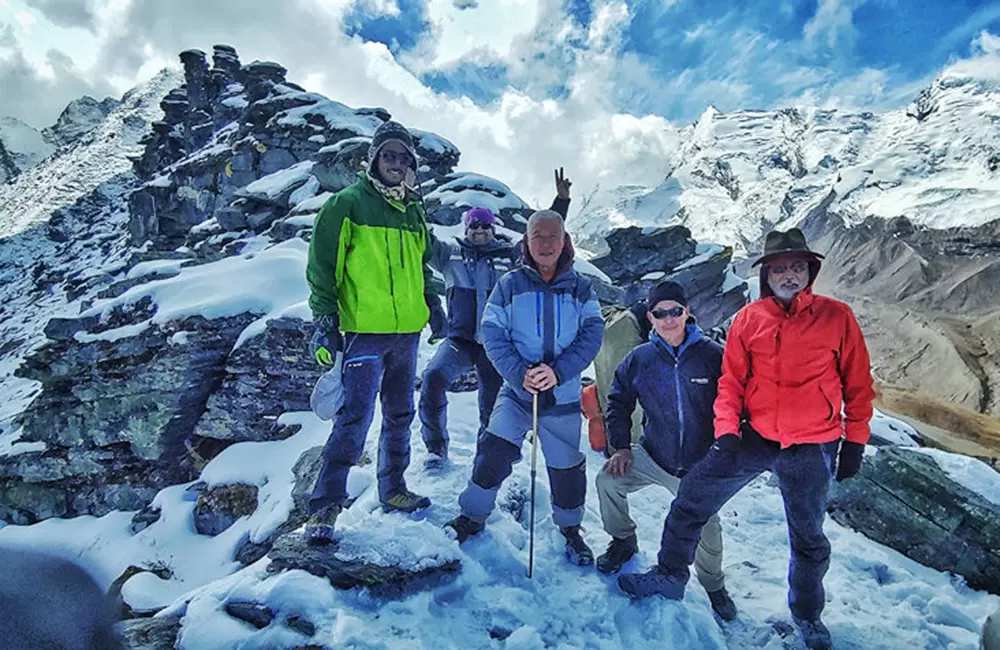
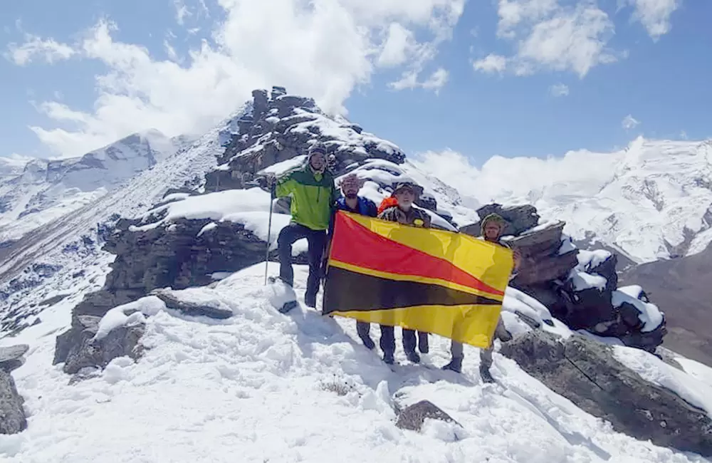
The distance to the top was just 1.5 kms. However a 65 degrees gradient slope, made slippery by fresh snow of the previous night, made us toil for 3 hrs 15 mins before we could taste the sweet success of standing high on Patangini Dhar at an elevation of 4915 mtrs (16,383’).The time was 1130 hrs. In the adrenalin induced high, all the toils and tribulations of the trek were forgotten.
A majestic 360 degree bird’s eye view of snow covered Nelang Valley peaks to the North; Manda, Bhrigupanth and Thalaisagar peaks to the North-East; Auden’s Col to the South East; Gangotri I, II, III and Rudragaira peaks to the South; greeted the eyes. It was Nature’s architecture at its awe inspiring best. Twin lectern clouds swirled overhead as if signifying God’s protective umbrella.
I took out The Mechanised Infantry Regiment flag, specially prepared for this occasion by Saroj, and got ourselves photographed atop Patangini Dhar. It was a moment of great joy and privilege. By 1200 hrs ominous dark clouds could be seen rising over Thalaisagar and Auden’s Col and moving rapidly in our direction. By 1230 hrs first flakes of snow started falling on us. God really had showered us with his benevolence by providing us with a six hours window of opportunity.
A quick consultation between Sandeep and Mahavir, our guide, ensued wherein decision was taken to abandon the attempt to ascend Auden’s Col and head directly for Upper Nala Camp in Rudragaira valley. With hindsight, it turned out to be the correct decision.
We commenced our descent from Patangini Dhar pass into Rudragaira valley by 1230 hrs. Light snowfall commenced immediately.Initial 2 kms descent was very steep. The snow covered stony ledges were extremely narrow. At places they were a mere 4-6 inches wide. Sandeep and Mahavir led the way down, literally carving out footsteps with the help of ice axes.We had our fair share of nervous moments where members of the group slipped on steep slopes. We also came close to losing some of our equipment and rations as it tumbled down the valley. However the brave porters recovered the bags after a long search.
Owing to continuous snowfall darkness set in early. We decided to camp mid-way, well short of Lower Nala Camp. Fresh water stream flowing adjacent to the camp provided ample water supply. It took us 4 hrs and 30 minutes to complete 4.5 kms of descent. It was 1730 hrs by the time we could set up our camp. Snowfall had stopped by now but the weather portends were not good.
TREK DAY 6 – RUDRAGAIRA VALLEY TO GANGOTRI
By first light there was already 2 inches of snow on the ground and visibility was down to 20 mtrs. There was bare minimum visibility owing to whiteout conditions.Nevertheless we started our return trek at 1030 hrs.Snowfall followed by intermittent rain dogged us throughout the day. Mahavir did a stellar job in route navigation and keeping the trek team in a compact formation.
Excitement of the day was the crossing of Rudragaira Nala short of Lower Nala Camp. C was no easy feat and the brave porters helped provide a safe passage for the crossing.After the Lower Nala Camp the pathway was well maintained by ITBP to support their expedition to Gangotri I peak and had a gentle slope which was easy to move on.After a 5 kms walk, we again crossed the Rudragaira Nala over a 20 mtrs long and 2’ wide wooden Log Bridge just 2 kms short of Gangotri. It was 1800 hrs by the time we reached Gangotri, having travelled a distance of 10 kms in 7 hrs and 30 mins.
SPECIAL THANKS
- To the porters, without whom the trek could not have been feasible. Nimble of feet, lightly clothed, carrying 20 kgs and even more of loads, they were ever cheerful. They are given one P for 20 kgs load, two Ps if carrying 40 kgs load. Some are known to carry upto 60 kgs load for three Ps, though on gentler slopes. Majority of them hail from Nepal and North East. One of the toughest and most dangerous way to earn livelihood!
- To Sandy, for accepting me into the group knowing fully well my liabilities of age and lack of trek experience. Even the suspicious looking medical certificate, required for his audit, did not make him bat an eyelid!
- To Rohan, taking in stride my announcement of accompanying him to the forthcoming Trek. In a matter of fact way he stated that it was one of the more difficult treks and I would be required to lug my own 12 kgs backpack! I dare not ask for any quarter and none was given. But he did keep a discreet over watch during the Trek.
- To my younger daughter Kaveri, for formulating a practice regime and ensuring I adhere to the prescribed routine, through Saroj.
- To Saroj, for accepting with alacrity my decision to go on the long trek and actively assisting me in my equipment and clothing procurement drive. Frankly speaking this did make me suspicious, initially. But as time flew by, my suspicions were proved to be unfounded. I am yet to get over this!
- To my elder daughter Arpana &elder son-in-law Saurabh, for not plying Saroj with end of the world theories.
- To all the Golden Oldies of my circle who try their best to keep me out of harm’s way, for avoiding negative sides and, though being careful enough to not volunteer themselves, did wish me the best.
Prologue
THROUGH THE JOURNEY OF TIME LIFE RENEWS AT FIFTY
Listen to hear my whispers in the Wind,
Look into time to see my footprints in Sand,
The whisper and footprint merge in Time.
I wonder at the Journey and cherish it again,
And the thought emerges the Journey is so young,
Beyond the Dunes the Mountains beckon.
Wonder at the ‘scape and new pastures I see,
As pathless wonder stretches beyond,
Realisation dawns it’s the Journey that counts.
Horizon is wide but the Mind goes beyond,
Gravity shackles the Body but never the Mind,
Give flight to the Mind and the Body goes along.
In unexplored vistas the Paths don’t matter,
The Journey’s end is the destination you reach,
You have engraved your Journey on the rocks of Time.
- Ibid


