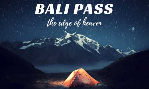
Within the kernels of Garhwal, lies the Bali Pass having an astounding elevation of 5,000 meters. This arresting high altitude pass offers unobstructed views of the sublime Himalayan peaks such as Kala Nag, Bandarpoonch, and Swargarohini.
The Bali Pass trek is full of adventures and mystical views that will make your trip nostalgic. The trek starts from Sankri village and ends at Jankichatti. A little trekking experience is necessary for commencing this trek.
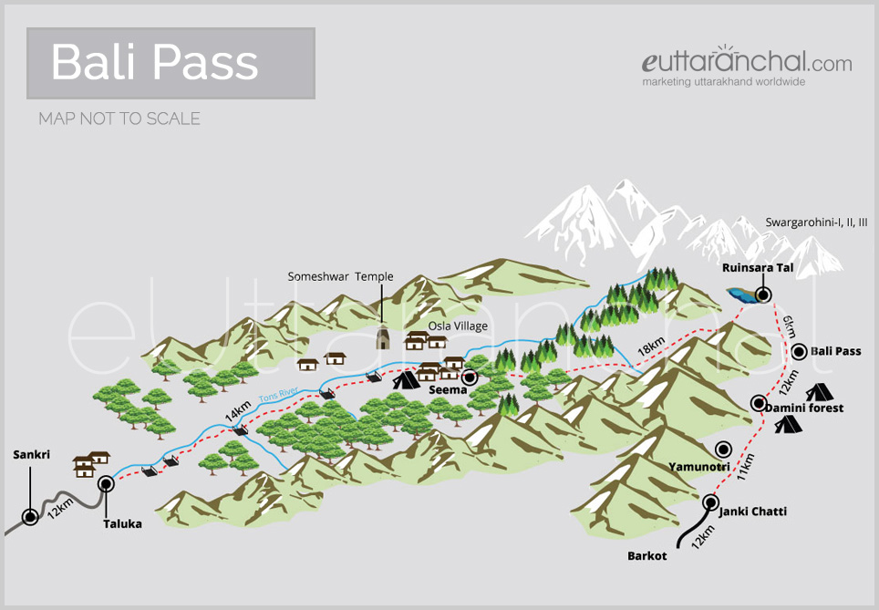
Get Bali Pass Trekking Guide, Route Map, Trek Itinerary
Bali Pass trek can be approached from Mid May to June End and early September to October Mid. The weather will be unpredictable during monsoon season and during winters the region will be exposed to heaps of snow.
eUttaranchal Bali Pass Trek Video
Bali Pass Travel Tips
Bali Pass is at an elevation close to 5000 meters, so, it will be better if you had a prior trekking experience.
It better to train yourself two-three months prior to participating in the trek.
If possible, arrive a day or two before you begin your hike to acclimatize yourself to the high-altitude climate and weather conditions.
Hire an experienced trekking guide to accompany you in your trek. These guides have much knowledge and expertise about the route.
Staying in Bali Pass
Situated in Govind Ballabh Pant sanctuary, trek to Bali Pass is a memorable one. At an elevation of 5,000m don’t expect a shed, let alone a lodge. Tents/camping are the only option. One can hire tents or even take their own when on a trekking expedition to Bali Pass.
Bali Pass Food Guide
Again, it is not possible for anyone to hold an eating joint at Bali Pass as it is a place with uninhabited by people at all. Trekkers can take the food supplies with themselves that they can purchase at lower altitudes, preferably before starting the trek. A cook can prepare a delicious cooked meal provided the entire ration is taken with.
Suggested Bali Pass Trek Itinerary
Day 1: Dehradun – Sankri (Drive – 200kms, 8hrs)
Start your journey from Dehradun, catch the morning bus to Sankri village from Mussoorie Bus Stand near Dehradun Railway Station. Alternatively, you can break your journey in two parts and take the bus or shared cab from Dehradun to Purola and then, from Purola to Sankri.
A swift 12 km jeepable road connects Sankri to Taluka. In case if the road is blocked due to the landslide, then you have to cover the distance on foot. It is an easy gradient which can be completed in just 3 hours. This trekking stretch will be fruitful for you as it will warm you up for the further trek.
The mild trail will take you through the thick forests of chestnuts, walnuts, and chinars. Taluka village is perched at an altitude of 2,410 metres above sea level and the trekking route from here to Seema is at the right side of the Supin river. Cross the wooden bridges hanging over the streams and climb uphill. While trekking, don’t be misguided by a couple of alternative routes that lead to the different villages of Jaunsar. On completing the 8 km trek, you will come across the pristine Gangad village ornamented by the unique wooden houses on the left side of the river. It takes 2 hours to reach Seema from here. For accommodation, there is a GMVN Guest House at Seema with a couple of shops and houses.
Day 3: Seema – Dev Thatch – Untigad Campsite/Ruinsara Tal (Trek – 18 kms)
Post breakfast; gear yourself up for a long day trekking. Follow the trail on the right, after walking past Seema. Don’t take the bridge over Supin River on the left as it leads to Har Ki Dun Valley. After 2 hours climb, the stunning view of the Dev Thatch meadow will come into view. This velvety Thatch meadow is 2 km in length but not much wide. You will enjoy walking on this meadow as the route turns out to be demanding from the end of Dev Thatch meadow to Untigad (3,500 metres.)
After crossing Dev Thatch, traverse to the surging Ruinsara Gad. The forest area of Ruinsara is blessed with nature’s munificence so you can enjoy photography here.
Day 4: Untigad Campsite/Ruinsara Tal – Bali Pass Base Camp (Odari) (Trek – 6 kms)
Overlooking the magnificent Himalayan peaks, lies the scenic Ruinsara Tal at 3,630 metres. This bejewelled lake is besieged by the birch trees which makes it an ideal campsite.
On reaching the Bali Pass base camp, take a deep breath, let go off the worries and absorb in the serenity of this place. You can also admire a ravishing view of the snow-shrouded Swargarohini peaks from here. Walk through the snowy pathways and reach the base camp. If you are fit to traverse further, then trek to the advanced base camp.
Day 5: Bali Pass Base Camp (Odari) – Bali Pass – Damini Forest Camping Ground (Trek – 12 kms)
Start off early at 4 am so you can reach Bali Pass before the change of weather. Since this the peak of the trek, so you might require carrying the trekking gears such as crampons and ropes. Watch out for crevasses after crossing the advance base camp. The silvery snowfields will take you to the glorious Bali Pass (4,950 metres). Trek towards the Yamunotri side. Make the steep and tricky descent to reach Damini camping ground.
From Damini trek down to the holy Yamunotri shrine, one of the Char Dhams of Uttarakhand and also the source of Yamuna River. After paying obeisance at the temple, trek down to Janki Chatti and then drive to Barkot.
Day 7: Barkot – Dehradun (Drive – 200kms, 8 hrs)
Bid adieu to the place and wrap up your journey by catching the early morning bus from Barkot that will take you to Dehradun.
Tourist Map of Bali Pass
Map for representation only. Map NOT TO SCALE.
Bali Pass Weather
Check out the Bali Pass weather report for April
Bali Pass Weather in April
The minimun and maximum temperature in April in Bali Pass is -15°C and 10°C respectively. The weather is generally chances of snowfall in April and you would feel cold throughout the day. Heavy Woolen clothes are recommended for Bali Pass in April.
eUttaranchal.com is NOT an Official website of Government of Uttarakhand (Uttaranchal) neither is it associated with Uttarakhand Tourism Board or KMVN or GMVN. Besides Uttarakhand Matrimonial and Uttarakhand Tourism services, eUttaranchal is also a mini encyclopedia of Uttarakhand providing information about Culture, Tourism, Education, Politics and News about Uttarakhand